offers a scenic and varied ride through Upper Lusatia and Saxon Switzerland.

Cycling
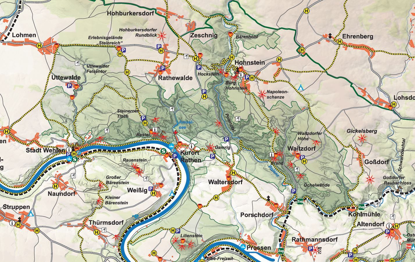
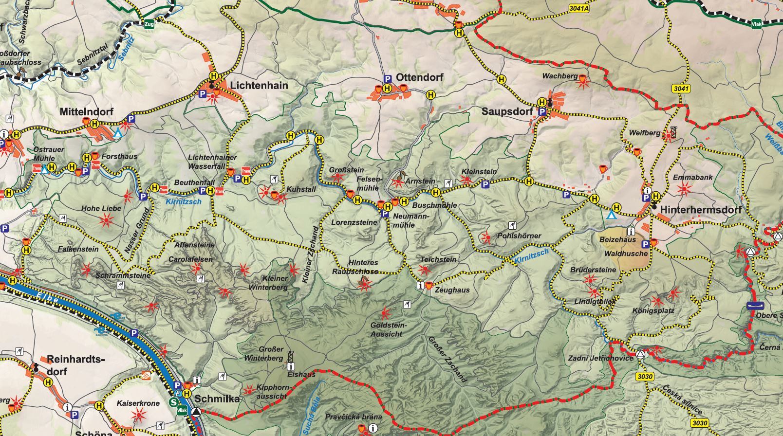
You can experience the natural beauty of Saxon Switzerland in a truly immersive way by bike. To this end, you have access to the transregional Elbe Cycle Route, the cycle paths within the landscape conservation area, around 50 km of official cycle routes in the national park, and links to the Bohemian cycle route network.
For cross-border trips to our neighbouring Bohemian Switzerland National Park, you can use the border crossings at Zadní Doubice (Khaatal/Hinterdaubitz) and Zadní Jetřichovice (Rabensteine/Hinterdittersbach) by bike.
To ensure you are well prepared for one of the varied cycle tours, we have compiled some useful information here to help you with your planning.

Where would you like to go?
Cycle routes in the national park
Trail markings & guideposts
Signage is the most important orientation aid in the Saxon Switzerland. The green signposts show destinations and trail names. They are supplemented by various trail markings. To help everyone find their way around, we explain the individual trail signs here.

Within the national park, green signposts bearing the yellow inscription ‘Radroute’ and a bicycle logo indicate the cycle routes in the area.

Outside of the national park, cycle routes are indicated with the usual green and white signs.

In the Bohemian Switzerland National Park, the cycle route network is indicated with yellow signs and for the most part follows asphalt trails.

In the landscape conservation area, cyclists may use all suitable trails and streets. Cycling on sport and educational trails as well as footpaths is not allowed.
Special features of cycling in the national park

In Saxon Switzerland National Park, cycling is permitted only on the official cycle routes. Cyclists are not allowed on any other paths. The national park cycle routes are clearly signposted.
Some sections of the routes in the national park run along unpaved forest tracks. In some places, you can expect challenging inclines and sections with a rough surface. On downhill sections in particular, you should watch out for deep ruts or pieces of wood laid across the path to help drain water. All cycle paths are also marked hiking trails, on which hikers always have priority. Please show due consideration!
As wild animals are particularly sensitive to disturbance at dusk and at night, and react much more skittishly to cyclists passing quickly than to slower movements, we ask you to avoid cycling at these times. Please also watch out for animals (e.g. toads and snakes) on the paths at all times of day.
There are no dedicated mountainbike or downhill trails in the national park.
The Saxon Switzerland National Park attracts many visitors and, as a large-scale nature reserve, is home to a unique flora and fauna. To ensure that everyone can continue to enjoy the beautiful landscape and nature in the future, a few special rules apply:
Only the official cycle routes may be used in the national park.
Access to the national park is only permitted on the existing paths to prevent erosion and give flora and fauna safe spaces. Paths may not be left. In the core zone, only marked or signposted paths or paths may be used.
Take your trash back to the next recycling bin, including tissues.
Smoking and any type of fire are prohibited. Campfires are only permitted at the designated fireplaces.
Always keep your dog on a leash. This protects local wildlife as well as your dog. Not all trails are suitable for dogs, please research before your trip.
Sleeping or camping in the national park is prohibited, this also includes sleeping in your caravan or car. The only exception is Boofen (bivouac under a rock overhang without a tent or tarp), which is only permitted from 16 June to 31 January, only for climbing and only in the official Boofen sites.
The use of drones or other aircraft is prohibited throughout the national park.
It is forbidden for people and animals to enter the water or swim in the national park.
Safe on trail

Anyone walking in the forest does so at their own risk. To help you better assess this risk, we have compiled some tips for you.

When deadwood collapses in the national park, it is not always possible to clear all paths promptly for health and safety reasons. These paths are temporarily declared impassable and should be avoided.

We provide an interactive map with temporarily closed or impassable trails as well as diversion options so you can plan your hike accordingly.